
PennDOT Resources for Effective Haul Route Planning
Learn how PennDOT’s public resources support better haul route planning through rich data, early risk visibility, and informed decision making.
.jpg)
Introduction
Haul route planning is one of the most important steps in early project development, especially for energy and infrastructure projects that rely on consistent truck access.
The goal is straightforward but critical: identify, evaluate, and manage how project-related traffic can safely and defensibly move between public roads and the project site, while minimizing risk to the project, local infrastructure, and community relationships.
The Pennsylvania Department of Transportation (PennDOT) offers developers a robust suite of resources that can make this process far more informed and far less reactive. When used together, these tools help teams validate assumptions, anticipate constraints, and make decisions that hold up under regulatory review and community scrutiny.
This article provides an overview of the PennDOT resources most valuable for haul route planning and explains how each one supports safer, more predictable project outcomes.
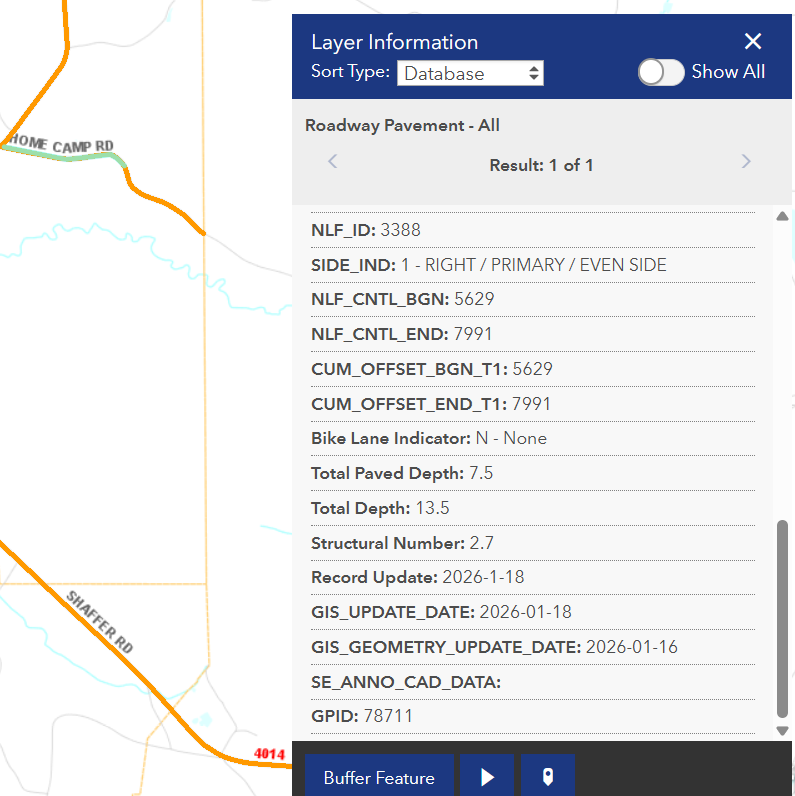
PennDOT One Map: A Central Hub for Roadway Intelligence
PennDOT’s One Map platform serves as a central access point for a wide range of roadway data. It brings together traffic volumes, pavement condition & history, and even future construction projects planned through Transportation Improvement Programs (TIPs). This consolidated view gives teams an early understanding of what the road network can realistically support.
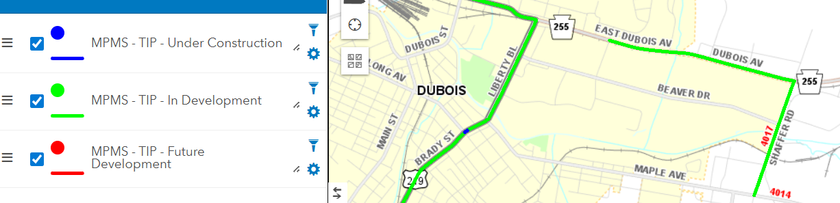
These layers can help answer important early questions, such as:
- Is a particular road capable of accommodating heavy truck traffic?
- Will a planned construction project disrupt haul routes in future seasons?
- Does the pavement history suggest potential load limitations?
For developers or haul route planners, this tool provides one of the first comprehensive looks at whether a route is feasible or if alternate planning will be necessary.
PennDOT Video Log: A Virtual Site Drive
The PennDOT Video Log platform allows teams to “drive” the full roadway from a desk, reviewing conditions, lane and shoulder widths, and potential physical constraints.
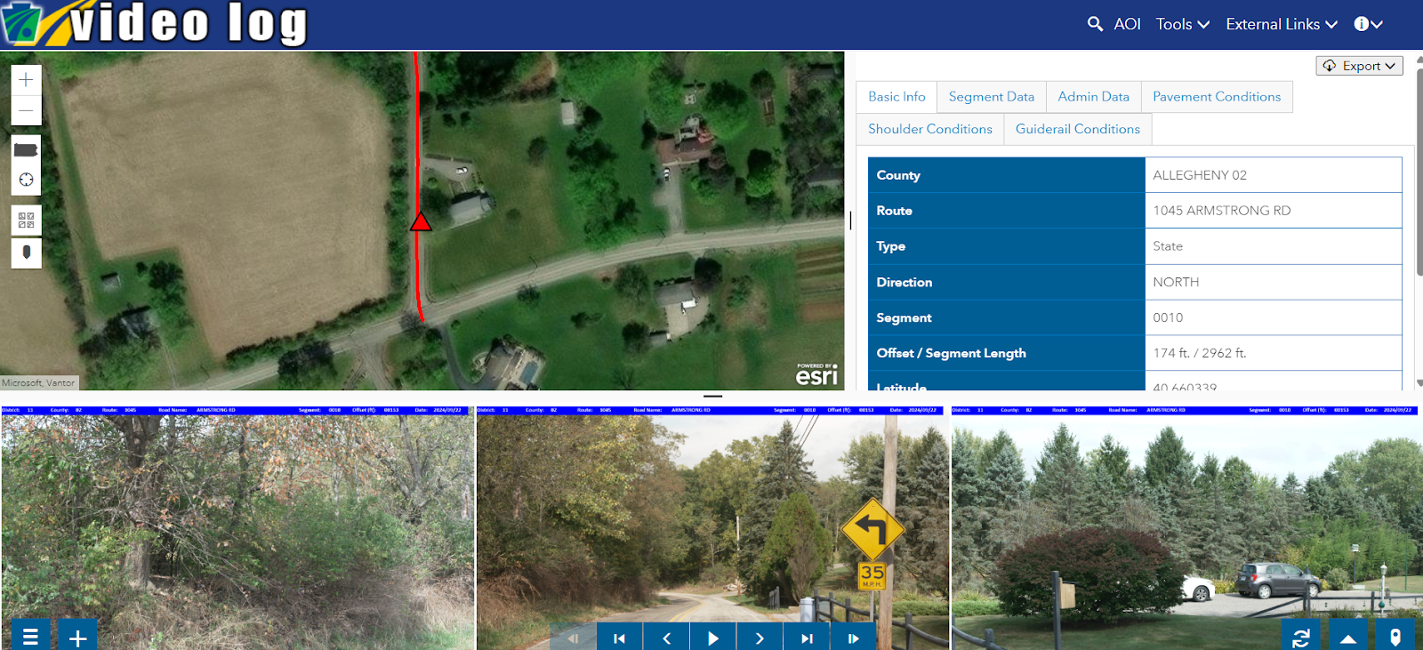
With access to critical information such as Segment and Offset details, pavement conditions, and traffic data, this resource is invaluable for identifying pinch points, encroachments, or sight distance limitations that are not always clear from static mapping tools.
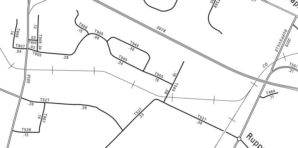
Type 10 and Type 5 Maps: Understanding Road Ownership
Road ownership has major implications for permitting, bonding, maintenance agreements, and approvals. PennDOT’s Type 10 and Type 5 maps make ownership clear at a glance.
Type 10 maps show the full county, outlining township and municipal boundaries while clearly differentiating state-owned, township-owned, and borough-owned roads. PennDOT-owned roads appear in pink or red, while township roads likely appear in gray.
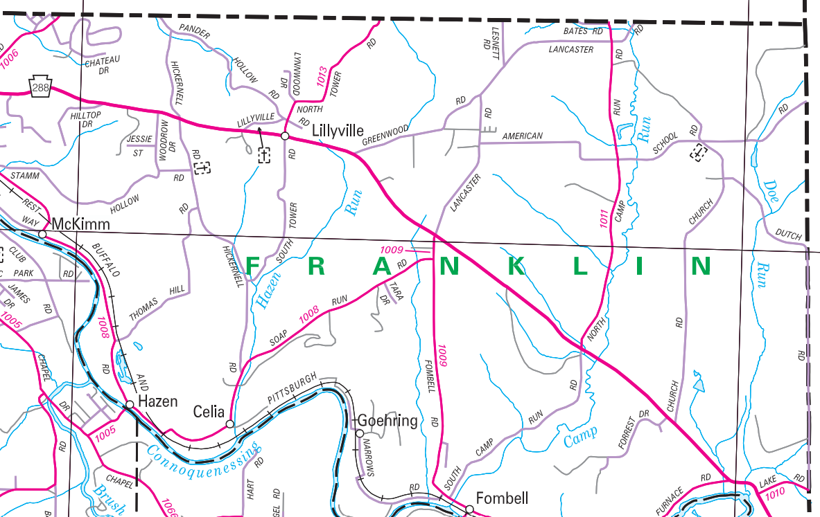
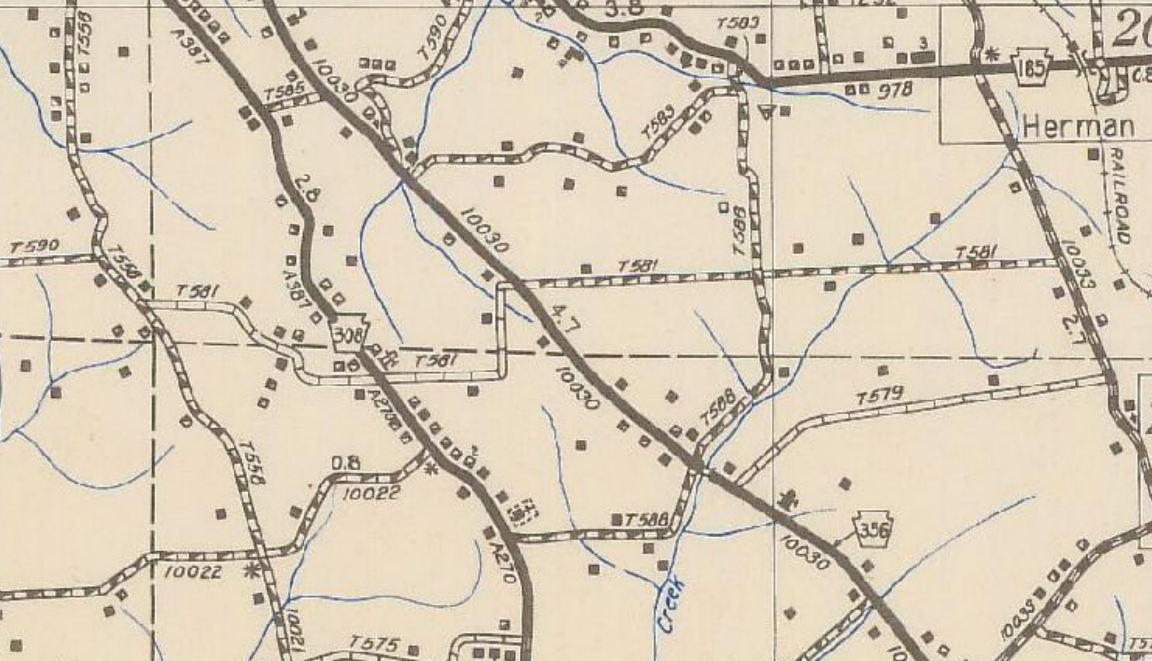
Type 5 maps provide even more detail at the township or borough level. They include details about:
- Road ownership
- Official township road names and numbers
- Centerline miles between intersections (helpful for road bonding calculations)
Historic Type 10 and Type 5 maps offer an additional layer of insight by showing how road ownership has changed over time. For instance, if a road was previously a state route and later transferred to local ownership, it may have been built to higher standards than a road that was always township-owned.
Posted and Bonded Roads Viewer: Essential for Regulatory Compliance
The Posted and Bonded Roads Viewer is a required tool for haul route planning in Pennsylvania. It identifies:
- State roads with posted weight limits
- Bridges with specific restrictions
- Safety-restricted roads
- Existing bonded users, their industries, and permitted limits
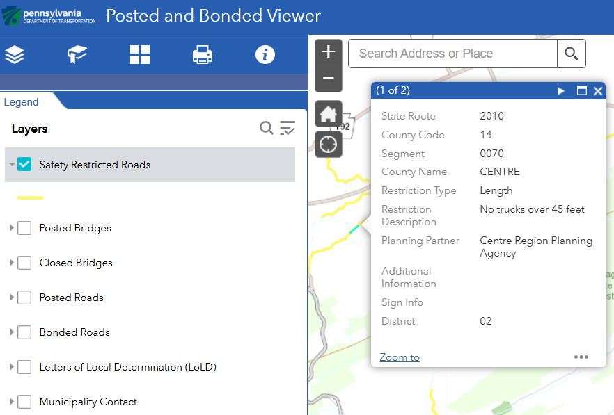
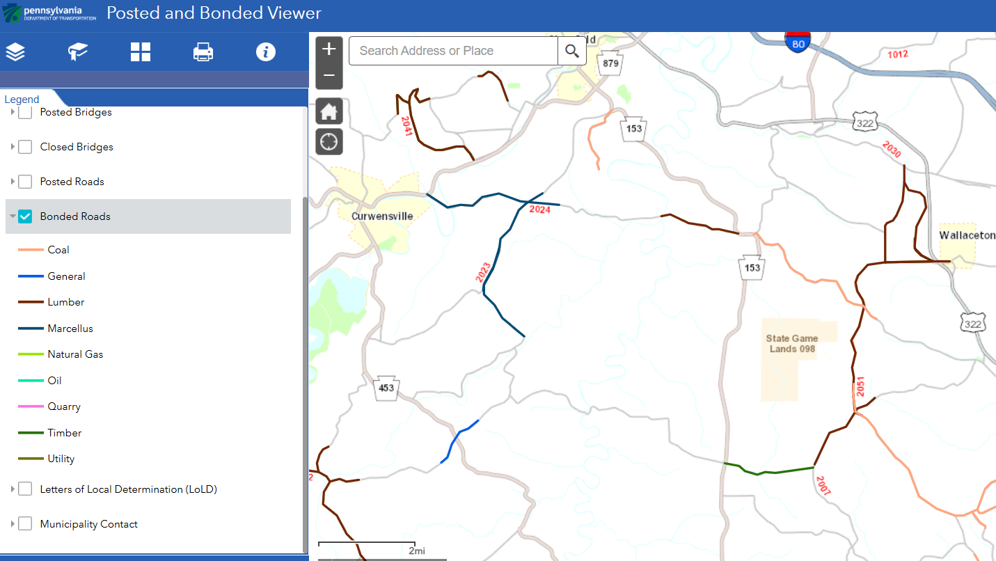
This information is essential for determining whether a route is legally viable or will require bonding, alternate paths, or coordination with PennDOT.
One limitation is that the data does not display which township or municipal routes have posted weight limits or safety restrictions. It does, however, provide contact information for these municipalities so teams can follow up directly. Site visits and conversations with local officials remain the most reliable way to confirm local weight limits or safety restrictions not reflected in state-level datasets.
PennDOT Bridges: Understanding Span, Condition, and Capacity
With more than 25,400 state-owned highway bridges (≥ 8 feet in length) and 6,600 locally owned bridges (>20 feet in length), Pennsylvania has the third-largest number of bridges in the U.S.
PennDOT provides detailed bridge inventory, condition, and clearance data that is crucial for haul route evaluations.

It is important to note that structures under 20 feet are not included in this dataset, even though they may still create hauling constraints. Identifying these smaller structures requires supplemental field verification.
Why These Resources Matter in Haul Route Planning
When used together, PennDOT’s resources and tools provide a full view of potential constraints before trucks ever hit the road. They allow teams to:
- Spot risks long before they become delays
- Confirm ownership and approval pathways
- Understand the physical and regulatory limitations of each segment
- Assess long-term feasibility, not just immediate access
- Strengthen defensibility with clear data and documented due diligence
For developers and logistics teams, this kind of preparation reduces uncertainty and builds trust with local municipalities. It also helps protect infrastructure, avoid costly repairs or bonding issues, and improve community relationships by ensuring road impacts are understood and managed.
Final Thoughts
Effective haul route planning requires more than identifying the shortest path. It demands a clear understanding of roadway conditions, ownership boundaries, weight restrictions, and future construction impacts. PennDOT’s publicly available resources offer a powerful foundation for that work.
By combining mapping tools, video logs, ownership maps, bridge data, and direct coordination with local officials, teams can build haul routes that are safe, legal, practical, and defensible.
Effective preparation not only reduces project risk but also helps maintain positive relationships with municipalities and ensures that the infrastructure supporting a project remains reliable for the communities that rely on it every day.
Energy Projects Need Roads
We Make Sure You Can Use Them—Legally, Smoothly, and Without Costly Delays.